Introduction
Robert Wilson Richmond
3rd September 2001
Robert Wilson Richmond
3rd September 2001
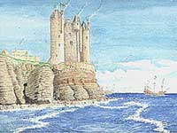 The artistic reconstruction by Andrew Spratt shows how the castle may have looked in 1595.
Keiss Castle is perhaps one of the best-known and most visible castles in Caithness lying some 10 miles south of John O’ Groats and 7 miles north of Wick. It occupies one of the most dramatic locations at the top of sheer cliffs overlooking the sea at the Northern end of Sinclair’s Bay.
 Access to the castle is by an easy 3/4 mile walk from Keiss Pier/Lang Head where there is ample car parking. You will pass some ancient broch sites on your way and as you approach the edifice you will be impressed by the elegance of the structure poised as it is right on the cliff edge, almost leaning back on itself as a precaution. It seems imposing from a distance but is really quite small and intimate close up.
 George, the 5th Earl of Caithness in the late 16th early 17th Century, built Keiss the exact year of its construction not being known. It was reputedly built upon the site of an earlier fortalice called “Raddar” but nothing of this now remains. The castle stood four stories in height plus an attic. Unfortunately the NE angle of the tower, which contained the entrance is gone, as have the upper floors. According to the Rev John Brand the castle was ruinous in 1700, but in 1726 it seems to have been in repair with “at the side of it a convenient house lately built”.
 Keiss Castle is oblong in plan with two round towers, one to the South of the SE angle and one projecting to the West at the NW angle. The latter round tower contained a wheel staircase in line with the North wall. The entrance doorway led directly into the ground floor chamber, off which, was the staircase. This staircase did not go all the way to the top but accessed the principal joisted floors on the 1st and 2nd levels. A smaller wheel stair in a projecting turret on the North side accessed the upper rooms. There was only one room on each level and the walls throughout are no thicker than 3ft 3 inches.
Great care should be exercised when visiting Keiss as it is in a dangerous state, with the curtilage of the site being fenced off. There have been recent collapses in the solum and under no circumstances should the structure be entered.
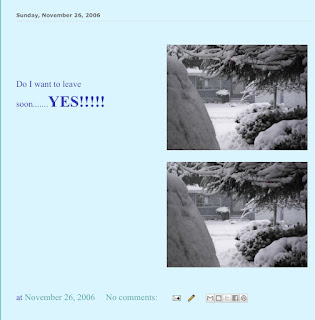
It was not a long hike to the castle..


Great location and amazing it is still standing considering the weather conditions around here!!


Descending Whaligoe Steps
The name Whaligoe seems to have come from 'Holy goe', suggesting an origin in early Christian times (goe means a rocky inlet). However, over time the name has been linked to whaling; several whale jawbones have been erected in the area and it seems likely that the original meaning has been lost.
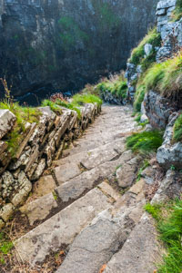
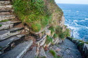
Telford may have dismissed the potential of Whaligoe, but Captain David Brodie was not convinced. Around 1793 he paid a local stone mason to create 330 stairs in the side of the cliff face, so that the narrow harbour at the bottom of the cliffs could be more easily accessed. The Steps are made of Caithness flagstone, as is a stone balustrade, the only concession to safety. The Steps take advantage of natural unevenness in the cliff face, and bend back and forth in a series of 5 hairpin turns.
A hairpin bend on the way down
But wait! Did Brodie actually have the Steps made? Perhaps not, for records from 1769 suggest that locals used steps here. It does seem that the Steps we see today were Brodie's brainchild, perhaps simply improving an existing set of stairs that were already in use.
The stairs zigzag down the cliffs to a narrow terrace just above the crashing waves. But how many steps are there? I confess I did not count, but locals dismiss the claims of the RCAHMS (Royal Commission of Ancient and Historical Monuments of Scotland) that there are 330 steps and insist that the correct number is 363, and Wikipedia says there 365. Whatever the exact number, the result is a simply amazing, a set of worn stone steps that seem to be suspended above a sheer drop, high above the rocky inlet far below.
Be under no illusions; the Whaiigoe harbour was a dangerous place; narrow and difficult to access even with the steps. Yet because the Caithness coast offered so few natural harbours, Whaligoe was used frequently by fishermen. The boats brought back herring, haddock, ling, and cod, which were unloaded at Whaliigoe and gutted by women on the small terrace known as The ink, above the harbour. The fish were then loaded into baskets and hauled up the steps to the top of the cliffs. They would then be transported to Wick for sale.
There was a cooperage at the top of the cliffs, and barrels from the cooperage were carried down the Steps and used for storing salted herring, which were then loaded onto ships for transport to market.
Even though the harbour was dangerous and the steps made transporting the fish arduous, Whaligoe was used by some 20 ships in the mid-19th century. Unfortunately, 14 of these were herring boats, and when the herring fishery declined in the late 1800s Whaligoe was gradually abandoned. Only 5 boats used the harbour by 1920, and it was completely abandoned by the 1960s.
That was not the end, however, for the picturesque Steps were maintained as a visitor attraction, albeit one that requires a fair bit of gumption to access and enjoy! The steps themselves are not signposted from the A99, but the hamlet of Whaligoe is, as is the cafe at the top of the cliffs.
There is a small parking area above the top of the steps, with a signed area for local residents, of which tere are few. rom thee a path leads past the Whaligoe Steps Cafe, a popular restaurant, to the top of the Steps. There are no information panels to describe the site, but then, you don't really need anything to distract you from the amazing and slightly unnerving beauty of the site.
Take care the steps can be slippery in wet weather, and there are no safety featured here beyond common sense. That said, anyone exercising reasonable care will have no trouble at all navigating the Steps. It will take roughly 5 minutes to descend, and, depending on how fit you are, double that time to come back up. At the bottom you can see the ruins of a salt storage shed on The Bink, and a winch used to help haul boats up onto the rocky shore.
The Whaligoe Steps ought to be more widely publicised; this is an awe-inspiring site, and it is amazing to think of the effort it took to carve the Steps out of the rocky cliffs, but also of how hard life must have been for the men and women who worked here, and ascended these cliffs in good weather and bad.

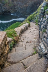
 The view from the bottom and I counted 335 steps!!!

On to my final stop you can Google Lybster to see where I am on the coast!!There was a cooperage at the top of the cliffs, and barrels from the cooperage were carried down the Steps and used for storing salted herring, which were then loaded onto ships for transport to market.
Even though the harbour was dangerous and the steps made transporting the fish arduous, Whaligoe was used by some 20 ships in the mid-19th century. Unfortunately, 14 of these were herring boats, and when the herring fishery declined in the late 1800s Whaligoe was gradually abandoned. Only 5 boats used the harbour by 1920, and it was completely abandoned by the 1960s.
Still going down ...
There is a small parking area above the top of the steps, with a signed area for local residents, of which tere are few. rom thee a path leads past the Whaligoe Steps Cafe, a popular restaurant, to the top of the Steps. There are no information panels to describe the site, but then, you don't really need anything to distract you from the amazing and slightly unnerving beauty of the site.
Take care the steps can be slippery in wet weather, and there are no safety featured here beyond common sense. That said, anyone exercising reasonable care will have no trouble at all navigating the Steps. It will take roughly 5 minutes to descend, and, depending on how fit you are, double that time to come back up. At the bottom you can see the ruins of a salt storage shed on The Bink, and a winch used to help haul boats up onto the rocky shore.
The Whaligoe Steps ought to be more widely publicised; this is an awe-inspiring site, and it is amazing to think of the effort it took to carve the Steps out of the rocky cliffs, but also of how hard life must have been for the men and women who worked here, and ascended these cliffs in good weather and bad.


Two weeks free subscription to the blog for the first one to spot Gran Coche negro(my car)!!!!


I enjoyed the hike along the cliff tops.....and what did I detect?? That around 2.30 pm the wind picks up and the heavy rain starts...good day I was inside my accommodation for the night...this is a B & B that I booked on Booking.com and it is quite lovely...4 other guests I have not seen....I have my own room, en suite and tea making facilities and use of the big lounge!!!


Some TV and more research tonight!!!
So about that contest..

Amazing zoom on my camera!!!

Yashi Kochi!!!!


2 comments:
Again, such beautiful scenery! Wow those steps look pretty steep but definitely a worthwhile trek down.
www.travelwithkevinandruth.com
every corner is lovely and different....L
Post a Comment